Weather Terms and Definitions
This page provides some basic weather terms and definitions which may appear on this site. At the end of some terms are links to further information.
Advisories • Barometric Pressure • Cloud Height • Dew Point • Heat Index • Humidity • Mesomap • METAR • Weather Station • Wind Chill • Further Reading
A statement generally provides additional or followup information to an existing weather condition.
An advisory is for less serious conditions that cause significant inconvenience and, if caution is not exercised, could lead to situations that may threaten life and/or property.
A watch is used when the risk of a hazardous weather event has increased significantly, but its occurrence, locations, and/or timing is still uncertain. It is intended to provide advance notice of possible inclement weather.
A warning is used for conditions posing an immediate threat to life or property. Depending on the type of warning, you should take immediate, appropriate action.
NOAA advisory types
National Weather Service Glossary
The air that makes up our atmosphere exerts a pressure on the surface of the earth. This pressure is known as atmospheric pressure. Generally, the more air above an area, the higher the atmospheric pressure. Barometric pressure changes with local weather conditions, making barometric pressure an important and useful weather forecasting tool. High pressure zones are generally associated with fair weather, while low pressure zones are generally associated with poor weather. For forecasting purposes, the absolute barometric pressure value is generally less important than the change in barometric pressure. In general, rising pressure indicates improving weather conditions, while falling pressure indicates deteriorating weather conditions.
The cloud height on this site is an estimate of cumulus clouds using a formula based on temperature and dew point. Actual measurements of cloud height are made with a ceilometer. This device fires a laser into the sky and measures the backscattered signal. Costs for such a device are beyond the scope of weather hobbyists.
Dew point is the temperature to which air must be cooled for saturation to occur. The dew point is an important measurement used to predict the formation of dew, frost, and fog. If dew point and temperature are close together in the late afternoon when the air begins to turn colder, fog is likely during the night. Dew point is also a good indicator of the air's actual water vapor content, unlike relative humidity, which takes the air's temperature into account. High dew point indicates high vapor content; low dew point indicates low vapor content. In addition a high dew point indicates a better chance of rain and severe thunderstorms. You can even use dew point to predict the minimum overnight temperature. Provided no fronts or other weather pattern changes are expected overnight, the afternoon's dew point gives you an idea of what minimum temperature to expect overnight.
Click here for more
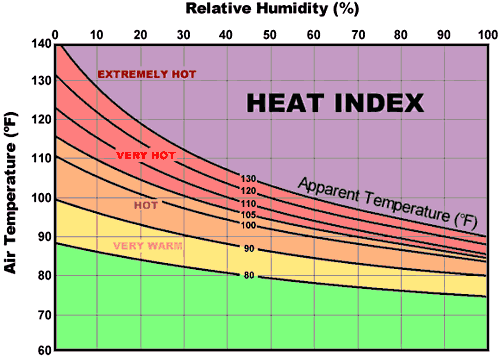
The Heat Index is a measure of relative discomfort due to combined heat and high humidity. It was developed by R.G. Steadman (1979) and is based on physiological studies of evaporative skin cooling for various combinations of ambient temperature and humidity. As temperatures climb above 90 °F and humidity goes above 40 percent, conditions are ripe for heat-related illnesses.

Humidity or relative humidity measures the amount of water vapor in the air relative to the temperature. It is important in weather because humidity affects how humans feel. A hot, humid day feels hotter because we cannot sweat as effectively. A cool, dry day feels colder because moisure evaporates more easily.
Click here for more
Mesomap is a combination of the terms "mesonet" and "map".
In meteorology, "mesonet" is a network of weather stations used to monitor weather over a regional area. Such stations gather data like temperature, pressure, humidity, wind speed/direction, cloud conditions, and precipitation.
A "map" is a graphical representation of some area.
Thus, a weather mesomap is a graphical representation of observing stations (usually surface stations) designed to display regional scale weather information. This allows an observer to gain a perspective of weather phenomena otherwise unobtainable.
Acroymn for METeorological Aerodrome Report. It is the primary observation code used in the United States to satisfy requirements for reporting surface meteorological data. Minimum reporting requirments includes wind, visibility, runway visual range, present weather, sky condition, temperature, dew point, and altimeter setting. Harrisburg Capitol City Airport (KCXY) is this site's primary METAR.
Click here for more
A weather station is a facility with instruments and equipment to make weather observations by monitoring atmospheric conditions to study the weather. This weather station has a thermometer for measuring temperature; barometer for measuring changes in air pressure; hygrometer for measuring humidity; anemometer for measuring wind speed and wind direction; and rain gauge for measuring precipitation. Our station also has non-traditional equipment like a webcam for visual weather observation and an electro-magnetic pulse counter for lightning detection.
More on Weather Station
More on Anemometer
More on Thermometer
More on Hygrometer
More on Rain Gauge
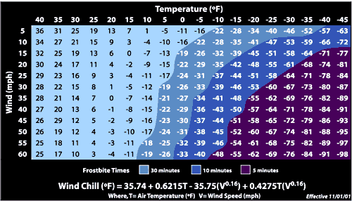
The wind chill temperature is what the temperature "feels like" to people and animals during cold weather. Wind chill is based on the rate of heat loss from exposed skin caused by wind and cold. As the wind increases, it draws heat from the body, driving down skin temperature and eventually the internal body temperature. Once temperatures drop below 10 °F and the wind is gusting, conditions are ripe for cold-related illnesses. Below -5 °F, any wind is a major factor in frostbite and hypothermia.
Click here for more


 NOAA Radio
  Meso Map
  Meso Map